The Ordovician sections along the western shore of the Hinlopen Strait, Ny Friesland, Spitsbergen were discovered in the late 1960s and since then prompted numerous paleontological publications; several of these publications are now considered classical in the literature of paleontology of Ordovician trilobites and of Ordovician paleogeography and stratigraphy. Our 2016 expedition aimed at a major recollection and reappraisal of these classical sites. Here we provide a first high-resolution lithological description of the Kirtonryggen and Valhallfonna formations (Tremadocian—Darriwilian), which together comprise a thickness of 843 m, a revised bio-, and lithostratigraphy, and an interpretation of the depositional sequences. We find that the sedimentary succession is very similar to successions of eastern Laurentia; its Tremadocian and early Floian part is composed of predominantly peritidal dolostones and limestones characterized by ribbon carbonates, intraclastic conglomerates, microbial laminites, and stromatolites, and its late Floian to Darriwilian part is composed of fossil-rich, bioturbated, cherty mud-wackestone, skeletal grainstone and shale, with local siltstone and glauconitic horizons. The succession can be subdivided into five third-order depositional sequences, which are interpreted as representing the Sauk IIIB Supersequence known from elsewhere on the Laurentian platform.
INTRODUCTION
The Ordovician sections along the western shore of the Hinlopen Strait (Hinlopenstretet), Ny Friesland, Spitsbergen, were discovered by accident in 1966, when an expedition team from the University of Cambridge stopped to collect water from a melt stream and collected several well-preserved trilobites (Fortey and Bruton, 2013). This discovery prompted two focused collection trips during the summers of 1967 (Vallance and Fortey, 1968) and 1972 (Fortey and Bruton, 1973) that resulted in a classic series of publications focused on the trilobite successions (e.g., Fortey, 1974a, 1974b, 1975a, 1975b, 1980) and accompanying fauna (e.g., brachiopods: Hansen and Holmer, 2011; conodonts: Lehnert et al., 2013; graptolites: Fortey, 1971; Cooper and Fortey, 1982; heterostracans: Bockelie and Fortey, 1976; mollusks: Evans and King, 1990; Morris and Fortey, 1976; ostracods: Williams and Siveter, 2008; radiolarians: Maletz and Bruton, 2005). Some of these publications have been influential in shaping approaches to paleogeographical reconstructions: at Hinlopen Strait the interplay between depth-related biofacies (“community types” of Fortey, 1975b), paleogeographical provinces, and sea-level fluctuation became evident (e.g., Cocks and Fortey, 1982). Other publications on the Hinlopen Strait succession had a significant impact on discussions about Ordovician stratigraphy. The Valhallan Stage was based on a section of the Hinlopen Strait; it was suggested in Fortey (1980a) to represent a time interval that previously has not been recognized in many North American sections because of a widespread hiatus on the continent. The Valhallan Stage, which is equivalent to the lower Dapingian Stage in modern terms, was never formally accepted, but its recognition was a significant step toward a supraregional stratigraphic correlation of this particular time interval (see Ross et al., 1997).
Despite the scientific importance of the Hinlopen Strait sections, very few subsequent expeditions have been made. It took 34 years, after which in short sequence three expeditions made stops in the area, collected Ordovician samples and remeasured the sections: In 2005 a group of the Polar Marine Geological Research Expedition (PMGRE) reappraised the sedimentary succession in context of a larger mapping project (Kosteva and Teben'kov, 2006); in 2007 a group from the German Bundesanstalt für Geowissenschaften und Rohstoffe (Federal Institute for Geosciences and Natural Resources) measured some sections at Hinlopen Strait and took biostratigraphic (conodont) samples in the context of their project Circum-Arctic Structural Events 10 (CASE 10) (Lehnert et al., 2013); and in 2008 a Norwegian-Swedish Group lead by Nils-Martin Hanken of the University of TromsØ visited the area and made some focused paleontological collections, but had bad luck with weather/snow conditions and polar bears (Hansen and Holmer, 2010, 2011). Consequently, no major attempt to resample the sections at Hinlopen Strait has been made since 1972. Further, no attempt has been made by any previous expeditionary team to describe and reconstruct the paleoenvironmental succession in detail.
The goal of our 2016 expedition was to measure and describe in detail the lithology and stratigraphy of the Ordovician rocks at its two main outcrop sites Profilstranda and Olenidsletta (fig. 1) and to collect paleontological and geochemical samples at high stratigraphic resolution. Herein, we provide the first results of this expedition, a detailed lithological description of the measured sections, a new high resolution stratigraphy, and an interpretation of the depositional sequences and its corresponding relative sea-level changes. The description will be the basis of a number of forthcoming publications with paleontological and geochemical focus.
GEOLOGICAL SETTING
The study area is on the northeastern edge of Ny Friesland on the island of Spitsbergen of the Svalbard archipelago, Norway, adjacent to the Hinlopen Strait (Hinlopenstretet), which divides Spitsbergen from Nordaustlandet (fig. 1). This region comprises two exposure areas of lower Paleozoic rocks of the Oslobreen Group, Hinlopenstretet Supergroup: one north (Basissletta) and one south (Olenidsletta) of the Buldrebreen arm of the Valhallfonna glacier at small cliffs along the coast line and in melt stream beds. The exposed sediments are subdivided into the Tokammane, Kirtonryggen, and Valhallfonna formations of the Oslobreen Group (Harland et al., 1966; Fortey and Bruton, 1973; Harland, 1997) and range from the Early Cambrian to the Middle Ordovician. The Kirtonryggen Formation comprises the Spora, Basissletta, and Nordporten members, and the Valhallfonna Formation is subdivided into the Olenidsletta and Profilbekken members (Fortey and Bruton, 1973; see details below). The Kap Sparre Formation in Nordauslandet on the eastern side of Hinlopenstretet is correlative to the Olsobreen Group, but high-resolution comparisons of the two are hampered by a of lack of biostratigraphic data in the former (Stouge et al., 2011). The pre-Carboniferous basement of the Svalbard archipelago consists of a number of tectonostratigraphically distinct terranes that were stretched along the margin of Laurentia in pre-Caledonian times (Gee and Page, 1994; Gee and Teben'kov, 2004). The study area is part of the Nordaustlandet terranes of eastern Svalbard, which in tectonic reconstructions are placed in close proximity to the Franz Joseph allochthon of northeastern Greenland (Smith and Rasmussen, 2008). During the mid-Paleozoic the sediments of the Hinlopenstretet Supergroup underwent minor folding with predominant NNW-SSE strike directions (Harland, 1997). The Hinlopenstretet Supergroup is generally little or not metamorphosed (Gee and Teben'kov, 2004).
In the southern outcrop area a roughly N/S directed Mesozoic dolerite intrusion limits the western expansion of the exposure of the early Paleozoic sediments. The intrusion is part of a complex of Late Jurassic-Early Cretaceous dolerites which are more widespread in the southern part of the Hinlopen Strait (Halvorsen, 1989).
MATERIAL AND METHODS
The data presented herein are the result of a joint expedition of the authors and the camp manager Hårvard Kårstad during July and August 2016. We traveled to Ny Friesland by boat and built a campsite at Profilbekken (79°50′17.9″N/017°42′19.9″W). The Olenidsletta area was accessible to us from Profilstranda across the Buldrevågen via rubber boat. During our expedition all visited sections were completely ice free.
We measured five sections using a Jacob's staff and clinometer, and tape measure (fig. 1): (1) The Spora River (SR) section and Profilstranda (PS) section form together a nearly continuous outcrop of the Basissletta and Nordporten members. The base of the SR section is within the Spora River channel just west of where the river crosses a small ridge formed by massive pinkish dolostones of the top Tokammane Formation (79°51′51.0″N/017°37′21.2″E). The SR section top is the topmost stromatolite bed at the mouth of the Spora River (79°51′57.4″N/017°38′33.2″E)
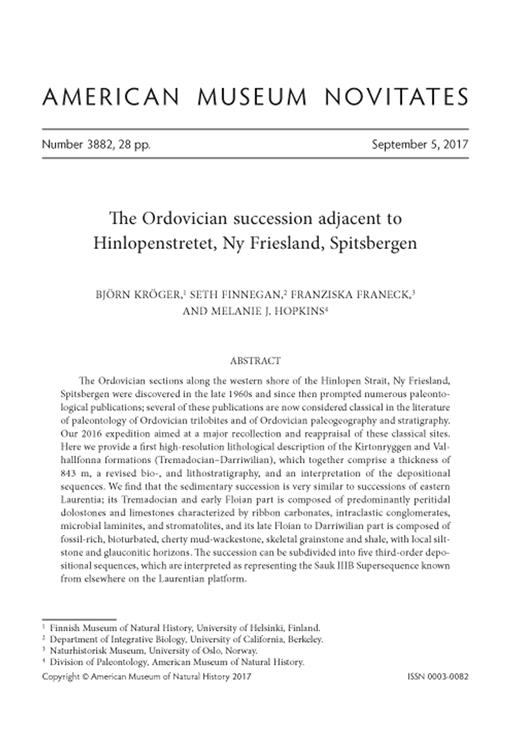
FIGURE 1.
Map of the outcrop area adjacent to Hinlopenstretet, Ny Friesland, Spitsbergen (Basissletta area in the north and the Olenidsletta in the south; inset is Svalbard, with Spitsbergen as its largest island). Measured sections in circles: FP, F-Promontory section; PO, Profilstranda-Olenidsletta Member section; PR, Profilbekken River section; PS, Profilstranda section; SR, Spora River section. The river names D, and E, and the promontory name F are the same as in Fortey and Bruton (1973: fig.1).

(2) The top of the SR section at the mouth of the Spora River is also the base of the PS section. We measured the upper part of the Basissletta Member and the complete Nordporten Member southward along the Profilstranda coastline. The outcrop is nearly continuous in its northern part with a minor fault and exposure gap at 59 m from the base of the section (79°51′41.2″N/017°39′51.5″E). A number of major exposure gaps occur higher up in the Basissletta Member ca. 50–200 m just north of the small headland that forms the base of the Nordporten Member (79°51′35.1″N/017°40′36.8″E). There the dolostones are covered by layers of modern beach gravel several meters thick. From the base of the Nordporten Member up to the Olenidsletta Member the outcrop is continuous. The top of the PS section is the uppermost prominent hardground within the uppermost Nordporten Member at 79°51′02.9″N/017°41′24.0″E.
(3) The top of the PS section is the base of the overlying PO section. The PO section is just the southward continuation of the Profilstranda coastline outcrop and ends at a mouth of a small melt stream at 79°50′49″N/017°42′04″E. The base of the Olenidsletta Member of the Valhallfonna Formation occurs within the first 5 m of the PO section.
(4) We measured a part of the Profilbekken Member along the Profilbekken River (section PR). The Profilbekken River cuts through the Profilbekken Member beds at a very low angle and the beds form a number of repeating folds and faults, which makes a reliable thickness measurement very difficult for a large part of the section. However, it was possible to measure a continuous ca. 45 m thick log from a place ca. 100 m upstream from the river mouth, where massive skeletal grainstone beds form a shallow ridge. This ridge is identical with the “basal algal conglomerate” ridge of Fortey (1980: 17); its top forms the top of the PR section at 79°50′36.1″N/017°43′04.5″E.
(5) We measured a complete section of the Profilbekken Member at the southern end of the Olenidsletta area. The top of the outcrop and the youngest beds of the Valhallfonna Formation occur at promontory F where the beds form a shallow syncline (79°46′43″N/017°54′20″E; fig. 1). We followed the anastomising melt stream just NW of promontory F in SW direction ca. 300 m upstream, which is stratigraphically downward. The outcrop is partly heavily weathered and in its upper part secondarily dolomitized.
DESCRIPTION OF SECTIONS
Tokammane Formation
General features: The uppermost ca. 40 m of the Tokammane Formation consist of a succession of three depositional units. The bases of these units are composed of buff-weathering, argillaceous, wavy-bedded, bioturbated, dolo-mudstone, flat-pebble and other intraclastic conglomerates, and thin-bedded dolo-siltstone with symmetric fine-scaled ripples. The top of each unit is formed by massive mounds of pinkish dolo-mudstone/dolo-wackestone, which contain thrombolitic and fenestral textures, and local patches of intraclastic conglomerates. The mounds have diameters of several tens of meters and at Spora River are thickest at the top of the formation. Each depositional unit is capped by an unconformity.
FIGURE 2.
Spora River (SR) section. Abbreviations: Fm, Formation; Mbr, Member. Explanation of symbols: 1, wavy bedded dolostone; 2, planar bedded limestone; 3, wavy bedded dolostone, burrow churned dolostone, ribbon dolostone; 4, laminated, planar bedded dolostone; 5, wavy narrowly bedded limestone; 6, laminated, planar bedded limestone; 7, argillaceous-shaly; 8, silty; 9, glauconitic; 10, thrombolitic, fenestral; 11, stromatolites; 12, oolites; 13, flint nodules; 14, flat pebble conglomerate; 15, general intraclastic conglomerate; 16, dispersed silica; 17, erosional surface; 18, hardground; 19, not exposed; 20, trilobites; 21, gastropods; 22, cephalopods; 23, sponges; 24, echinoderms; 25, articulate brachiopods; 26, inarticulate brachiopods.

Detailed description: The measured section at Spora River (fig. 2) starts at a ca. 0.5 m massive flatpebble conglomerate, which has a fining-up tendency of intraclasts and an erosive 3 cm irregular top. The overlying 5 m of buff-weathering, wavybedded dolo-mudstone are topped by a ca. 2 m thick massive, pinkish, fenestral dolo-mudstone. In the top 0.15 m of this pinkish mudstone, domal stromatolites occur that are up to 0.5 m in diameter.
The second unit begins above an erosional base with ca. 10 m of a monotonous, buff-weathering, wavy-bedded, argillaceous dolo-mudstone. In the lowermost beds of this unit parallel tunnels of unknown burrowers with diameters of less than 10 mm are common. At the top of this dolostone, a more massive, pinkish unit above an erosional base marks the base of the third unit. In the lower 0.2 m, this unit is composed of patches of poorly rounded intraclastic conglomerates; above this is a 25 m layer of fenestral dolo-mud and dolo-wackestone, partly with a thrombolitic texture. Around 2 m into this unit (at 19 m in the section), this massive dolostone is interrupted by a 1 m layer of thin-bedded, platy- to wavy-bedded, dolo-siltstone that contains areas with small scale, symmetrical ripples and patches of flat-pebble conglomerates. Above this dolo-siltstone is a covered interval of about 10 m, overlain by the top 13 m of the Tokammane Formation, which are formed by massive, pinkish, thrombolitic mounds (fig. 3A).
FIGURE 3.
Field photographs of details of the Tokammane and Kirtonryggen formations, Furongian?, Cambrian-Tremadocian, Ordovician, Spora River (SR) section, Ny Friesland, Spitsbergen. A, pinkish thromboliticfenestral dolostone of the uppermost Tokammane Formation, at SR section ca. 40 m; B, burrow-mottled dolostone of the uppermost Spora Member, at SR section 63 m; C, partly silicified domal stromatolite with underlying flat pebble conglomerate, at SR section 148 m.

Kirtonryggen Formation
Spora Member
We measured the Spora Member at its type locality at Spora River, which we estimated to have a thickness of ca. 20 m. The base of the member is well defined by a prominent erosional surface with a more than 1 m high relief, which cuts into the underlying Tokammane Formation. The lower ca. 10 m of the Spora Member consist of massive, dark-grey, burrow-churned, wavy-bedded, fossil-rich dolo-mudstone/dolo-wackestone. At its lower 2 m, black flint nodules and thin flint layers are abundant. At a position of ca. 3 m from the base, a distinctive ca. 0.3 m intraclastic conglomerate with rounded ca. 10–30 mm large pebbles occurs. Fossil abundance peaks at ca. 5–7 m above the base of the member, and the fauna is dominated by small ophiletid gastropods (diameter ca. 20–30 mm) and ellesmerocerid and endocerid cephalopods. Toward the top, the dolostone becomes more light colored, buff weathering, partly burrow mottled (fig. 3B), and rich in distinct trace fossils that form a network of tunnels with diameters of ca. 10 mm (fig. 4A). The top of the Spora Member is lithologically transitional toward the lower Basissletta Member.
Basissletta Member
General: The Basissletta Member, exposed at Spora River and Profilstranda, is ca. 289 m thick. We placed the base of the member above the uppermost ca. 1 m of burrowmottled limestone, about 20 m above the base of the Kirtonryggen Formation. Compared to the Spora Member, the lithology in the lower Basissletta Member is composed of purer, and more light-colored, buff-weathering, platy- to wavy-bedded, burrow-churned to homogenous, sucrose dolo-mud to dolo-siltstone. Burrow-mottled horizons and distinctive trace fossils are nearly absent. The middle part of the member is highly condensed with abundant erosional surfaces, flat-pebble conglomerates, oolite beds, and horizons with massive dark flint nodules and columnar to dome-shaped stromatolite beds. In its upper part argillaceous beds dominate and interchange with skeletal dolo-wackestone to dolo-packstone that contain abundant gastropods and trilobites. The boundary with the overlying Nordporten Member is transitional.
Details: The lower ca. 58 m of the Basissletta Member consist of buff-weathering, mostly planar-bedded, homogenous to burrow-churned dolo-mudstone to dolo-siltstone. Within this interval two horizons occur that have a burrow-mottled texture and contain rare gastropods, cephalopods, and sponge macrofossils (at ca. 15 m, 46 m above member base = at positions 80 m, 111 m in the SR section, respectively). The lowermost stromatolites occur as a compact, up to 0.2 m thick layer on an erosional surface at ca. 123 m in the section. Columnar and domeshaped stromatolites, ooid layers, intraclastic and flat-pebble conglomerates, cross-lamination textures, and erosional surfaces are common throughout the following 30 m (figs. 3C, 5). The most prominent erosional surface cuts as a more than 0.5 m thick intraclastic conglomerate with a relief of ca. 0.3 m into a wavy-bedded dolostone with low domal stromatolites at ca. 71 m above the base of the member at 136 m in the SR section.
FIGURE 4.
Field photographs of bedding surfaces with trace fossils in originally soft sediments of the Kirtonryggen and Valhallfonna formations, Tremadocian-Darriwilian, Ordovician, adjacent to Hinlopenstretet, Ny Friesland, Spitsbergen. A, Upper Spora Member, at Spora River section 62 m; B, Nordporten Member, at Profilstranda (PS) section 234 m; C, upper Basissletta Member, at PS section 107 m; D, uppermost Profilbekken Member, at F-promontory section 5 m.

At the mouth of the Spora River, at the top of the SR section, ca. 88 m above the base of the Basissletta Member, the stromatolite-rich interval is succeeded by ca. 40 m of massive yellowish-grey weathering, fine-laminated dolo-siltstone, that is exposed along the coast of Profilstranda (fig. 6A). This interval contains in some places hummocky cross stratification (fig. 6D) and is partly rich in flint nodules. Flat-pebble and other intraclastic conglomerates occur at 101 m and 122 m above base of Basissletta Member (at 13 m and 34 m in PS section, respectively; fig. 7). Toward the top of this interval dark-grey weathering, flint-rich, partly nodular, argillaceous dolostones and ribbon dolostone are more common.
FIGURE 5.
Field photographs of intraclastic horizons of the middle Basissletta Member, Kirtonryggen Formation, Tremadocian, Ordovician, Spora River (SR) section, Ny Friesland, Spitsbergen. A, intraclastic conglomerate over erosional surface, at SR section 142 m; B, oolitic ripple horizon within laminated dolo-mudstone at SR section 143 m; C, flat pebble conglomerate, at SR section 147 m; D, flat pebble conglomerate with gutter cast and vertically oriented clasts, at SR section 150 m.

At 135 m and 146 m above the base of the Basissletta Member (at 47 and 58 m in PS section, respectively), two horizons with low domal stromatolites, intraformational and flat-pebble conglomerates, oolites, and erosional surfaces occur. Remarkable are teepee structures in a pyrite-rich dolostone (fig. 6C) that are underlain by a flat pebble conglomerate and overlain by a dark-weathering, argillaceous, nodular, bioturbated dolostone at ca. 138 m above the base of the Basissletta Member (at PS section 50 m). A ca. 0.5 m oolite bed above a massive intraformational conglomerate and below a bed of stromatolites at 145 m (at PS section 57 m) serves as a good local-marker horizon.
The upper part of the Basissletta Member is partly poorly exposed, covered or fault disturbed along the coast along Profilstranda (fig. 7). The exposed parts can be subdivided into three units. The lower ca. 20 m unit is predominantly a yellowish weathering, wavy-bedded, bioturbated dolo-mudstone rich in large flint nodules. The nodules are up to 0.4 m in diameter and 0.3 m in thickness. The middle ca. 30 m unit is rich in intraclastic and flat-pebble conglomerates, erosional surfaces, channels, cross bedding textures and contains predominantly light yellowish-grey, burrow-mottled, nodular dolostone and ribbon dolostone. Toward the top of this middle unit, hardgrounds locally occur on the top of intraclastic, channel-rich dolostone beds. The topmost flat-pebble conglomerate of the Basissletta Member occurs at 198 m above the base of the member (at PS section 110 m). The uppermost unit of the Basissletta Member is a ca. 90 m thick, partly covered alternation of beds of yellowish-grey, argillaceous, wavy-bedded to nodular, burrow-churned dolo-mudstone, more massive stylolithic burrow-churned dolo-wackestone, and tempestitic skeletal-intraclastic dolo-packstone with common trilobite hash and gastropods.
FIGURE 6.
Field photographs of bedding features of the Basissletta Member, Kirtonryggen Formation, Tremadocian, Ordovician, Ny Friesland, Spitsbergen. A, laminated dolo-mudstone, at Profilstranda (PS) section 5 m; B, argillaceous interval above flat pebble conglomerate bed, at PS section 87–88 m; C, teepee structures in laminated dolo-mudstone, at PS section 50 m; D, hummocky cross stratification, at PS section 4 m.

Nordporten Member
General: The Nordporten Member, exposed at Profilstranda (fig. 7), is ca. 217 m thick. We placed the base of the member at the basal bed of a succession of massive reddish-grey weathering, burrow-churned dolo-mudstone/dolo-wackestone, rich in gastropods and trilobites, which forms the northernmost point of a small headland at Profilstranda (79°51′35.1″N/017°40′36.8″E). This bed forms the upper transitional part of an alternation of massive dolo-wackestone/dolo-mudstone and argillaceous mudstone. The transition from the Basissletta Member is gradual into a ca. 50 m thick, more massive succession of burrow-mottled dolostone to ribbon-dolostone with erosional-topped/hardground-based repetitive units. Above this succession another ca. 50 m are principally very similar but contain more commonly hardgrounds, prominent grainstone-packstone lithologies, and scattered intraclastic horizons. The upper ca. 120 m of the Nordporten Member consist predominantly of monotonous massive grey to brownish burrow-churned, cherty dolo-mudstone/dolo-wackestone. Toward the top, the succession gets more massive and hardground horizons are more common.
FIGURE 7.
Profilstranda (PS) section, Basissletta and Nordporten members, Kirtonryggen Formation, Tremadocian-Floian, Ordovician, adjacent to Hinlopenstretet, Ny Friesland, Spitsbergen. For explanation of symbols see figure 2.

FIGURE 8.
Field photographs of discontinuity surfaces within the Nordporten Member, Kirtonryggen Formation, Floian, Ordovician, adjacent to Hinlopenstretet, Ny Friesland, Spitsbergen. A, at Profilstranda (PS) section 219 m; B, at PS section 277 m.

Details: The base of the Nordporten Member is drawn at the base of a ca. 5 m massive dolostone within the upper part of the transitional unit of alternating massive dolostone and nodularto wavy-bedded argillaceous mudstone. At a position of ca. 11 m (PS section 209 m) below a prominent erosional surface/hard ground with an underlying 0.2 m oolite. This discontinuity surface is the lowest of six similar erosional surfaces (at 20 m, 29 m, 31 m, 34 m, 44 m above member base = at PS section 219 m, 227 m, 229 m, 232 m, 242 m, respectively; fig. 8), each of them with an erosional relief of less than 0.3 m, that are associated with horizons of intraclastic conglomerates and/or oolite beds. On the top of some of these discontinuity surfaces, characteristic micromud mounds or microbioherms with diameters of ca. 0.3 m and thicknesses of less than 0.2 m occur that commonly contain trilobites and gastropods. The microbioherms are embedded in a matrix of planar-bedded, greenish-grey, argillaceous mudstone, and form the base of the six repetitive units. In each of the units the basal mudstone grades into wavy-bedded to nodular, greenish-grey mudstone to ribbon dolostone, and finally into massive, burrow-churned dolo- mudstone/ dolo-wackestone. The more argillaceous intervals commonly contain networks of unbranched burrows of the Gordia trace fossil type (fig. 4B) and hummocky cross stratification. At ca. 56 m above the base of the Nordporten Member (PS section 254 m), a ca. 0.4 m thick intraclastic conglomerate bed marks the base of a gradual facies transition towards more massive dolostones with common intraclast horizons, grainstone, and packstone layers. At ca. 65 m above the base of the member (PS section 263 m), a ca. 1.5 m thick pair of brachiopod-rich (Hesperonomia sp.) grain-packstone layers forms a marker horizon, which can be seen as the climax of this intraclast-rich succession. The most pronounced erosional surface cuts with a relief of more than 1 m into an underlying dolo-packstone/dolo-grainstone lithology at 79 m above the base of the member (PS section 277 m; figs. 7, 8B). The uppermost of these discontinuity-capped packstone/grainstone layers occurs at 116 m above the base of the Nordporten (PS section 314 m) within a ca. 50 m succession very rich in chert nodules. The top of a gradual facies change is marked by a prominent hardground at 162 m above the base of the Nordporten Member (PS section 360 m) leading to ca. 60 m of very massive, grey-weathering, nodular, heavily bioturbated mudstone/wackestone lithologies with common discontinuity surfaces and hardgrounds that are most densely concentrated near the top of the member. The top 3 m of the formation are very rich in cephalopods and gradually change toward darker, more argillaceous mudstone lithologies.
FIGURE 9.
Profilstranda-Olenidsletta Member (PO) section, Olenidsletta Member, Valhallfonna Formation, Floian-Dapingian, Ordovician, adjacent to Hinlopenstretet, Ny Friesland, Spitsbergen. For explanation of symbols see figure 2.

Valhallfonna Formation
Olenidsletta Member
General: The Olenidsletta Member comprises a succession of dark limestone and black mudstone with a transitional lithology at its lower boundary. At Profilstranda the thickness of the Olenidsletta Member is approximately 160 m (fig. 9). A precise thickness specification is impossible for the Profilstranda section because the uppermost part is locally covered and the boundary interval crops out only a few hundred meters SW in the Profilbekken River section. We placed the base of the Olenidsletta Member 3 m within the cephalopod-rich limestone that marks the transition interval from the Nordporten to the Olenidsletta Member (79°51′02.9″N/017°41′24.0″E.). This boundary bed marks the top of the underlying massive, hardground-rich limestone unit of the Nordporten Member and is 6 m below the uppermost cephalopod occurrence within the transitional interval. The top of the member is not now exposed at Profilstranda, but at the nearby Profilbekken River, where it can be traced in several places across repeating fold sections (see below). Lithologically, the Olenidsletta Member can be roughly subdivided into four transitional intervals. The lowermost 5 m are predominantly composed of dark, massive, stylolithic, bioturbated lime-mudstone with cephalopod coquina/cephalopod packstone interlayers. The overlying ca. 87 m are an alternation of densely laminated, dark lime-mudstone and bituminous black shale with bedding thicknesses varying between 0.05 m and 0.3 m, which are intermittently rich in graptolites. This shale-rich interval is overlain by a ca. 35 m interval of a more carbonaceous limestone/shale alternation with abundant hardgrounds and beds of burrow-churned to nodular limestone, rich in trilobites, cephalopods, and inarticulate brachiopods. The upper ca. 30 m of the member are again dominated by black shale intervals.
Details: The lower part of the Olenidsletta Member is characterized by a gradual disappearance of bioturbated limestone horizons, an increase of black shale intervals and a gradual decrease in abundance of cephalopods and trilobites. A collection made at 1.5 m above the base of the member included the trilobites Tropidopyge alveus and Carolinites genacinaca nevadensis, confirming that this part of the section is in the lowermost interval of the Olenidsletta Member (V1a of Fortey, 1980). At 11 m, trilobites of the overlying V1b interval (Balnibarbi ceryx, Psilocara patagiatum) were found. No cephalopods were found in any beds between 5 m to 97 m above the base of the member. A peak in graptolite abundance occurs ca. 70–90 m above the base of the Olenidsletta Member. The presence of Balnibarbi pulvurea and Balnibarbi erugata at 73 m and B. pulvurea at 90 m above the base of the member indicates that this part of the section is in the V1c interval of Fortey (1980). A conspicuous flint layer that serves as a local marker horizon occurs at 87 m above the base of the member. A flat conspicuous hardground at 94.4 m above the base of the member caps a ca. 1.5 m bioturbated limestone interval with thickening up tendency. This hardground marks the onset of a succession of more than a dozen very similar repetitive units. Many of these units start with bituminous black shale rich in large inarticulate brachiopods, that grade into massive, nodular, bioturbated lime-mudstone lithologies containing abundant large trilobites and orthoconic cephalopods. At 99 m above the member base, the hard ground marking the top of one of the repetitive units is overlain by a thin intraclastic conglomerate. At 119 m, and 126–129 m, the limestone contains abundant flint nodules. The bituminous lower sections of the repetitive units are especially rich in large inarticulate brachiopods (mostly Ectenoglossa) in the interval 95–110 m, and 123 m above the base of the member. This interval (V2a of Fortey, 1980) is also characterized by the large asaphid trilobite Gog catillus, the lowest occurrence of which was found at 103 m above the base of the member. The top layers of the repetitive units at 119 m, 121 m, and 128 m are exceptionally rich in cephalopods and trilobites and contain horizons with trilobite hash/cephalopod shell packstone. The orthoconic cephalopod shells are current aligned (fig. 10A). We place the boundary between V2a and V2b of Fortey (1980) around 123 m above the base of the member (fig. 9) based on the occurrence of late-form Bienvillia stikta, late-form Symphysurus arcticus, and Hypermecaspis sp. in the interval 123–125 m; this is supported by the occurrence of Ampyx porcus and Lyrapyge ebriosus (both V2a) at 120.3 m above the base of the member. The uppermost shale-rich part of the member begins above the hard ground at the top of one of the repetitive units at 128 m. The boundary between V2 and V3 is transitional (Fortey 1980), but we place it no higher than 129 m above the base of the member. In this part of the member, the bituminous black shale/limestone is especially rich in large olenid trilobites. The upper part of the member consists of repetitive units with thickness of up to 3 m, each topped by a massive decimeter-thick limestone bed, which is partly bioturbated and capped by a flat hardground. Small orthoconic cephalopods (less than 3 mm in diameter), trilobite fragments, and 3D preserved graptolites are common within the top limestone layers of each of the units (fig. 10C).
FIGURE 10.
Field photographs of bedding surfaces of the Valhallfonna Formation, Floian-Darriwilian, Ordovician, Basissletta area, adjacent to Hinlopenstretet, Ny Friesland, Spitsbergen. A, surface with masses of fragments of orthoconic cephalopods, current aligned, upper Olenidsletta Member, Profilbekken River (PR) section, bed correlates with bed at 128 m at Profilstranda-Olenidsletta Member (PO) section; B, flat hardground with small borings and ophiletid gastropod, Olenidsletta Member, at PO section 90 m; C, bedding surfaces with masses of minute orthoconic cephalopods and trilobite hash, uppermost Olenidsletta Member, PR section; D, endocerid cephalopod with microbial overgrowth on iron (limonitic) stained hardground in Profilbekken Member, at PR section 0 m.

Although not exposed along Profilstranda, the base of the Profilbekken Member is marked by an inarticulate brachiopod-rich phosphatic, skeletal packstone, which represents a thin horizon covering the topmost of these repetitive units. This boundary layer is exposed in Profilbekken and near promontory F in the Olenidsletta area south of Buldrebreen (fig. 1).
Profilbekken Member
General: The thickness and the lithology of the Profilbekken Member vary across the outcrop area. The complete section of the Profilbekken Member exposed along the F-promontory melt stream (section FP; fig. 11) is ca.157 m thick. The member is also well exposed at Profilbekken River, but difficult to measure, because of faulting and folding of the beds. A part of the middle Profilbekken Member could be measured at Profilbekken River, but the correlation is problematic because of the lack of common distinct marker beds (fig. 12). At the FP section the Profilbekken Member largely consists of an alternation of well-bedded, slightly silicified, yellowish-grey, banded lime-mudstone (fig. 13A) and wavy-bedded, bioturbated to nodular grey lime-mudstone, with a few prominent hardground horizons and more argillaceous greenish-grey intervals. In contrast, the section at Profilbekken River is divided into distinct silty-glauconitic beds and horizons dominated by intraclastic-skeletal grainstone and packstone lithologies. The upper boundary of the member is exposed only in the southern outcrop area, and at section FP it is drawn at the base of the gray-green siltstoneshale unit that caps the massive limestone of the top Profilbekken Member. The upper ca. 10 m of the Profilbekken Member are composed of a massive, light grey weathering, bioturbated lime-mudstone/lime-wackestone with abundant hardgrounds and omission surfaces. The top of the limestone succession is formed by a prominent hardground and/or erosional surface with a ca. 0.1 m relief. A greenish bed of siltstone-marl, rich in orthid brachiopods and pelmatozoan debris overlies this top hardground with an exposed thickness of 4 m and forms the youngest of the beds of the Valhallfonna Formation.
Details: The base of the member is a thin (few centimeters) skeletal packstone layer, rich in inarticulate brachiopod (obolids) shell hash and trilobite cuticle fragments (Fortey and Bruton, 1973). The horizon has been found at section FP and in several places along the Profilbekken River, where it was impossible to reconstruct a coherent profile. At Profilbekken River it is evident that similar more or less phosphate-rich, thin, skeletal packstone beds exist in the top few meters of the Olenidsletta Member. These beds contain trilobite hash, brachiopodshell hash and small orthoconic cephalopods in a varying amount and are representative of the termination of individual meter scale repetitive units with thickening-up limestones at the top of the Olenidsletta Member (fig. 10C). At section FP (figure section FP; fig. 11), no such phosphate-rich horizon exists above the base of the Profilbekken Member, but the dark, partly bituminous argillaceous-silty, laminated lime-mudstone, characteristic of the upper Olenidsletta Member continues for ca. 3 m until it grades into a 21 m succession of well-bedded, grey lime-mudstone that is partly silicified and during weathering forms characteristic yellowish-grey bands, Hardgrounds and discontinuity surfaces occur in some places in this banded limestone. A prominent hardground 11 m above the base of the member contains abundant large orthoconic endocerid cephalopods and trilobite hash. The particular limestone below the hardground is well bioturbated and irregularly bedded; directly above the hardground a thin intraclastic conglomerate occurs. A similar prominent hardground horizon occurs at 33 m above the member base. The monotonous alternation of banded silicified limestone and wavy-bedded bioturbated limestone at section FP is interrupted only by two more-argillaceous, greenish-weathering, partly flint, nodule-rich beds with transitional boundaries at 52–53 m and at 78–79 m from the base. It is questionable whether and how these two argillaceous limestone beds relate to the distinct glauconite intervals that occur at Profilbekken River.
FIGURE 11.
F-promontory (FP) section, Profilbekken Member, Valhallfonna Formation, Dapingian—Darriwilian, Ordovician, adjacent to Hinlopenstretet, Ny Friesland, Spitsbergen. Note that the thickness measure in meters counts downward. For explanation of symbols see figure 2.

FIGURE 12.
Profilbekken River (PR) section, Profilbekken Member, Valhallfonna Formation, Dapingian—Darriwilian, Ordovician, adjacent to Hinlopenstretet, Ny Friesland, Spitsbergen. Symbols: a = algae; Y = spiculae; for other symbols see figure 2.

At Profilbekken River the lithology is much more variable in the middle part of the member with two prominent glauconite intervals that serve as local marker horizons (fig. 12). The upper glauconite interval consists of three distinct up to 1.5 m glauconite-siltstone beds at 24 m, 29 m, and 31 m (fig. 13B). Each of the glauconite beds caps a prominent bored hardground on top of the respective underlying bioturbated massive limestone. The lower glauconite interval at 4 m is comprised of a succession of 4-5 glauconite silt beds, each with a thickness of ca. 0.1 m. The hardgrounds of the lower glauconite interval differ from those in the upper interval in being strongly iron stained (fig. 13B). Generally the lower glauconite interval appears to be very rich in dispersed pyrite. The lower glauconite interval also differs from the upper interval in containing abundant large orthoconic endocerid cephalopods, trilobites, gastropods (fig. 10D). Large monaxon sponge spicules and orthid brachiopods are common in the limestone beds between the two glauconite intervals. Crinoid ossicles are abundant throughout the measured Profilbekken section, but clearly increase in abundance toward the top, where several up to 2 m algal-pelmatozoan grainstone beds form the top of individual hardground-capped repetitive units.
FIGURE 13.
Field photographs of features of the Profilbekken Member, Valhallfonna Formation, Dapingian— Darriwilian, Ordovician, adjacent to Hinlopenstretet, Ny Friesland, Spitsbergen. A, typical banded, silicified, lime-mudstone of the Profilbekken Member, at PR section ca. 10 m; B, iron (limonitic) stained hardground with prominent vertical borings, at PR section 0 m; C, upper glauconite bed, at PR section 32 m.

STRATIGRAPHICAL SUBDIVISION AND CORRELATION
Problems in Lithostratigraphic Subdivision
The lithostratigraphic subdivision of the sections described herein is based on units established by Gobbet and Wilson (1960), Harland et al. (1966), and Vallance and Fortey (1968). The formations and members are adopted without changes from Fortey and Bruton (1973). This is common practice in all publications about the Hinlopen Strait sections since the 1970s. Nonetheless, the thickness estimates given in the some of these publications vary dramatically. The most extreme differences exist between measurements of Kosteva and Teben'kov (2006) and Lehnert et al. (2013) with total thicknesses of the Kirtonryggen and Valhallfonna formations of 722 m and 1055 m, respectively. Our own measurement with 843 m is nearly 100 m more than the thickness given in Fortey and Bruton (1973).
The reason for these differences must not be sought for in dissenting practices of placing boundaries of the two formations because these two boundaries are unmistakably defined by Fortey and Bruton (1973). Instead, we assume that most of the discrepancies result from differences in the combination of sections from either the northern Profilbekken or the southern Olenidsletta outcrop area and/or from differences in ice conditions. During the 1971 expedition David Bruton recorded much ice in the sections and ice was also present in the sections during the 1967 expedition (D. Bruton, personal commun.). This is in contrast to our 2016 expedition with complete ice- and snowfree conditions. Our combined section of the Profilbekken and Olenidsletta area is based on the combination of one more or less continuous outcrop in the northern area that starts at the Spora River in the north and continues south along the shore of the Profilbekken and a second one along the F-promontory melt stream in the southernmost part of the outcrop area. We did not find any major fault-related repetition or gap in these outcrops. But an additional short section of the Profilbekken Member along the Profilbekken River illustrates the existence of significant lateral facies changes between the northern and the southern outcrop area in the Profilbekken Member with greatly reduced thickness in the northern outcrop area (fig. 14). The opposite trend seems to exist within the Olenidsletta Member: we measured a thickness of ca. 160 m in the northern area whereas Fortey and Bruton (1973) report a total thickness of 145 m based on measurements in the type area in the southern outcrop. We also found slightly different thicknesses than Fortey and Bruton (1973). Our data of the Olenidsletta Member are in general agreement with the biostratigraphy summarized at the end of the volume by Fortey (1980) in a pull-out chart that lists all trilobite species. The Olenidsletta Member trilobite range zones V1 and V2 are reported to have a thickness of 77 m and 29 m, respectively, in Fortey (1980), measured at the Olenidsletta type section. These correspond to our thicknesses of 95 m and 34 m measured at Profilstranda (fig. 9).
It continues to be impossible to create a combined section exclusively from either the northern or southern outcrop area. Hence, any combined section of the Hinlopen Strait Ordovician reflects an individual synthesis across a relatively large area with significant facies and thickness changes.
Additionally, it can be expected that discrepancies in the individual attempts to correlate between the sections led to differences in the composite log; for example, the largest difference between our measurement and that of Fortey and Bruton (1973) is within the Basissletta Member. We measured a total thickness of 289 m for the Basissletta Member whereas Fortey and Bruton (1973) measured 250 m at the same section. This difference is best explained by improved outcrop conditions since the 1970s due to less ice and snow coverage. In our section the Basissletta Member contains two intervals with stromatolites; one crops out at ca. 60–90 m above the base of the member within the Spora River and another at ca. 140–150 m above the base along the Profilbekken shoreline. The Fortey and Bruton (1973) section contains only our lower stromatolite interval. But the Profilbekken shoreline, which was easily accessible to us, was difficult to access 44 years ago (Fortey and Bruton, 1973: 2232). We did not find any signs of a major tectonic repetition of the section and are confident that the Basissletta Member contains two stromatolite-rich intervals. In our opinion the discrepancy of ca. 40 m between the two measurements results from a missing middle part of the Basissletta Member in the Fortey and Bruton (1973) section.
A third source of discrepancies is the sometimes ambiguous placing of the member boundaries in section intervals with gradual lithology changes. The original description in Fortey and Bruton (1973) is explicit, but did not prevent permissive reinterpretation by some authors. The base of the Nordporten Member, e.g., is defined as “a 10 m-thick, massive, fossiliferous gray limestone forming a small headland 2 km to the north of the Profilbekken” (Fortey and Bruton, 1973: 2232). But it appears that Lehnert et al. (2013) placed their Nordporten Member base at a position ca. 80 m lower in the section at a place some 100 m toward the north of this small headland.
FIGURE 14.
Stratigraphic scheme of the Ordovician adjacent to Hinlopenstretet, Ny Friesland, Spitsbergen.

It is important to have these discrepancies in mind when comparing individual fossil occurrences or lithologies from the different published composite sections. These discrepancies and differing practices in logging also set important constraints for high-resolution biostratigraphic and chronostratigraphic correlations.
Problems in Biostratigraphy and Correlation with Chronostratigraphy
The biostratigraphy of the Kirtonryggen and Valhallfonna formations is primarily based on trilobites, and was first established in great detail within the Valhallfonna Formation with nine successive trilobite faunal (or assemblage) zones (Fortey, 1980). The list of trilobite faunal zones was completed for the Kirtonryggen Formation by Fortey and Bruton (2013). The conodont stratigraphy is based on Fortey and Barnes (1977), Lehnert et al. (2013), and a few samples discussed in Fortey and Bruton (2013). A graptolite-based stratigraphy was published only for the Olenidsletta Member (Archer and Fortey, 1974; Cooper and Fortey, 1982).
Conflicting biostratigraphic data occur partly within the Kirtonryggen Formation. The Spora Member contains trilobites that have been correlated with the Laurentian Leiostegium-Tesselecauda trilobite zones of Ross et al. (1997), Stairsian Regional Stage, by Fortey and Bruton (2013). In contrast, the only productive conodont sample from the Spora Member, comes from the very top of the member and contains a fauna of the Laurentian Rossodus manitouensis conodont zone, Skullrockian-Stairsian regional stages (Lehnert et al., 2013). Currently no additional fossil data are available to further constrain the age of the Spora Member.
The biostratigraphy of the Basissletta Member is problematic, because the fossils are rare and endemic. Trilobites collected at the base of the lower stromatolite interval (ca. 60 m above the base of the Basissletta Member) and in fossil-poor dolo-mudstones ca. 104 m above the base of the Basissletta Member are interpreted to represent an interval that is not deposited elsewhere on Laurentia (Fortey and Bruton, 2013). Conodonts recovered from the top of the lowermost stromatolite interval ± 90 m above the base of the member contain the index taxon of the Macerodus dianae conodont zone (sample BS122 of Lehnert et al., 2013). A sample from the topmost Basissletta Member contains conodonts indicative of the Laurentian Oepikodus communis conodont zone (Fortey and Bruton, 2013: 9–10) and trilobites in the uppermost Basissletta-lowermost Nordporten Member can be correlated with the Laurentian Benthamaspis rochmotis-Petigurus cullisoni trilobite zones interval (Fortey and Bruton, 2013: 14), which in turn correlates with the lower part of the Oepikodus communis conodont zone. Hence, the base of the Floian Stage can be expected within the upper part of, but not at the top of, the Basissletta Member.
The biostratigraphy of the Nordporten to lower Profilbekken members is well resolved and the trilobite, graptolite, and conodont data are consistent. But few data are available for the Profilbekken Member. Conodonts collected from a bed between the two main glauconite horizons at Profilbekken River indicate a stratigraphic position within the Paroistodus originalis-Baltoniodus norrlandicus conodont zones and within the Isograptus victoriae maximodivergens-Levisograptus graptolite zones (sample BS66 of Lehnert et al., 2013) near the Dapingian-Darriwilian stage boundary. The trilobites above a level of ca. 30 m in the Profilbekken Member section of Fortey and Bruton (1973) are considered to be correlative with the Whiterockian Orthidiella trilobite zone of Laurentia, but this level could not be located with confidence in our sections, and it is questionable whether it is below BS66 of Lehnert et al. (2013) at the position near the lowermost glauconitic horizons.
This short overview reveals that large intervals of the Kirtonryggen and Valhallfonna formations need a better biostratigraphic resolution, but with the current data the possibilities are limited. A higher biostratigraphic resolution of the sections is also crucial for a reliable interregional correlation of the depositional sequences of the Hinlopen sections.
Sequence Stratigraphy
The succession of the Kirtonryggen and Valhallfonna formations is in several aspects very similar to time-equivalent carbonate successions of the eastern paleomargin of Laurentia, and can be directly compared with the Early to early Middle Ordovician carbonates of the central Appalachian Basin (compare Pope and Read, 1998; Brezinski et al., 2012) and of western Newfoundland (compare Pratt and James, 1986, Knight and James, 1987; Knight et al., 2007). The Kirtonryggen Formation is mainly composed of fossiliferous bioturbated mud-wackestone, ribbon carbonate, intraclastic (predominately flat-pebble) conglomerate, grainstone and oolite, and microbial laminite. These lithologies form units that shallow up in parasequences on a scale of meters to tens of meters.
In comparison, the Lower Ordovician part of the Knox Group of the central Appalachians consists of a number of third-order depositional sequences that are composed of dozens of meter-scale shallowing-upward peritidal parasequences with common flat-pebble conglomerates and oolites at their base, low domal stromatolites in their middle parts, and cryptal laminites at their top. The deeper depositional settings of this part of the Knox Group consists of subtidal ribbon carbonates and more massive microbial bioherms (Pope and Read, 1998). On western Newfound-land the Lower Ordovician part of the St. George Group consists of peritidal carbonates that range from supratidal cryptalgal laminates, intertidal ribbon carbonates, and stromatolites to deeper subtidal thrombolite mounds and fossiliferous wackestone (Pratt and James, 1986).
This general similarity of the carbonate successions of eastern Laurentia, including those of Spitsbergen, is even more compelling when considering their general change in sedimentation style toward the Middle and Late Ordovician. The uppermost parts of the Nordporten Member and Olenidsletta Member record a substantial rise in sea level accompanied by a change of the lithology toward dark, bituminous mud-wackestone and shale lithologies. At the top of the Olenidsletta Member and within the Profilbekken Member the sea level returned to levels comparable to that of the Nordporten Member, but the lithology does not return to a Kirtonryggen facies. Instead the Profilbekken lithologies are dominated by massive mud-wackestone, partly rich in dispersed silica and/or chert, skeletal pack-grainstone (rich in pelmatozoan ossicles and algal fragments), shale-siltstone, and glauconite-rich beds. In the Profilbekken Member, the limestone forms parasequences with thicknesses of a few to tens of meters with shale-siltstone beds at their bases, mud-wackestone beds as main parts, and partly skeletal grain-packstone layers at their top. The parasequences are capped by prominent hardgrounds, which are heavily bored on, and may be phosphate or iron encrusted. With the exception of the glauconite beds, this facies is very similar to the High Bridge and St. Paul Group of Kentucky and Virginia (Pope and Read, 1998). This Early to Late Ordovician facies change across eastern Laurentia has been interpreted as reflecting major climatic change during the Ordovician (Pope and Read, 1998; Pope and Steffen, 2003).
FIGURE 15.
Correlation of of the Ordovician adjacent to Hinlopenstretet, Ny Friesland, Spitsbergen with selected successions of eastern Laurentia (eastern United States and Canada). Based on Cooper et al. (2012); Landing et al. (2011), and Lavoie et al. (2012).

Despite this general similarity in facies pattern it is difficult to correlate individual depositional sequences of the Kirtonryggen and Valhallfonna formations with that other regions of Laurentia. Five third-order depositional sequences can be distinguished within the Kirtonryggen and Valhallfonna formations (fig. 14). Generally, the five sequences can be interpreted as part of the Laurentian Sauk IIIB Supersequence (Morgan, 2012), which is sandwiched above the prominent basal Tremadocian Stonehenge transgression (Taylor et al. 1992) and below the Darriwilian base of the Tippecanoe Supersequence. The exact stratigraphic range of the hiatus at the base of the Kirtonryggen Formation is not known, and the onset of sedimentation of the Spora Member was either during the latest Skullrockian or during the earliest Stairsian regional stages (see above). But it is clear that the fossil-rich bioturbated dolostone of the Spora Member represents a deep setting that is not represented again until the upper part of the Basissletta Member. The interval between the Spora Member and the upper Basissletta Member contains two major shallowing events, both of which are Stairsian in age. Therefore, the Spora Member most likely represents the late part of the Stonehenge transgression, and the two successive lowstand intervals within the Basissletta Member can be interpreted as equivalents of the widespread Laurentian early Stairsian unconformity (e.g., top Stonehenge Formation, central Appalachians; base Boat Harbor Formation, western Newfoundland; base Rochdale Formation, New York; Tule Valley lowstand, Utah; see Morgan, 2012), and late Stairsian unconformity (e.g., Rochdale/Fort Cassin formations unconformity, New York; Boat Harbor unconformity, western Newfoundland; see Morgan, 2012), respectively. Consequently, our sequence I would be roughly equivalent with the upper part of the lower Boat Harbour Formation in western Newfoundland, and our sequence II would be partly equivalent with the middle Boat Harbor Formation in western Newfoundland and the Rochdale Formation in New York (fig. 15). This correlation is consistent with the biostratigraphic data of the Basissletta Formation (Fortey and Bruton, 2013; Lehnert et al., 2013). A detailed correlation of the overlying sequence III is not possible with the available data, but the massive deepening at the topmost Nordporten Member/basal Olenidsletta Member can be confined with some confidence to a prominent early Floian Laurentian transgression around the O. communis/O. evae conodont zone boundary (e.g., Laignet Point Member, western Newfoundland; Fort Cassin Formation, New York; evae-transgression, northeast Greenland; see Morgan, 2012). The massive sea level drop at the lower Profilbekken Member is in accordance with the “basal widespread Whiterockian regression” and a succession of unconformities at the Floian/Dapingian boundary ultimately mark the top of the Laurentian SAUK supersequence (Morgan, 2012).
CONCLUSIONS
The Kirtonryggen and Valhallfonna formations comprise 843 m of mostly carbonaceous Early to early Middle Ordovician sediments. The sedimentary succession is in several aspects very similar to other successions of eastern Laurentia; its Tremadocian and early Floian part is composed of predominantly peritidal dolostones and limestones characterized by ribbon carbonates, intraclastic conglomerates, microbial laminites, and stromatolites, and its late Floian to Darriwilian part is composed of fossil-rich, bioturbated, cherty mud-wackestone, skeletal grainstone and shale, with local siltstone and glauconitic horizons. The succession would be consistent with a general trend of Early to Middle Ordovician climate cooling.
Lateral facies differentiation complicates the local correlation of the upper Valhallfonna Formation, especially in the absence of a high-resolution biostratigraphy on this part of the succession. The biostratigraphic resolution of the Kirtonryggen and Valhallfonna formations greatly varies, depending on the position within the succession. The more restricted, shallow peritidal carbonates of the Basissletta Member contain a sparse and endemic assemblage, which cannot be directly correlated with other Laurentian areas. A comparatively high-resolved biostratigraphy is possible within the graptolite rich shales and mud-limestones of the Olenidsletta Member.
Within the Kirtonryggen and Valhallfonna formations, five third-order depositional sequences can be subdivided, and are interpreted as representing the SAUK IIIB Supersequence known from elsewhere on the Laurentian platform. A detailed correlation of the individual third-order sequences is currently difficult because of limited biostratigraphic control, but the available data suggest that especially the Stairsian and Middle Ordovician lowstand intervals are much more complete than in other Laurentian sections.
ACKNOWLEDGMENTS
We are grateful for the general support during preparation and realization of the project by David Bruton (Natural History Museum [NHM], Oslo, Norway), Ebony (Longyearbyen, Svalbard, Norway), Ethan (Profilbekken, Svalbard, Norway), Richard Fortey (NHM London), Nils Martin Hanken (Tromsø/Oslo, Norway), Håvard Hansen (Norsk Polarinstitut, Svalbard, Norway), Stig Hennigsen and family (Longyearbyen, Svalbard, Norway), Jim Johansen (Norsk Polarinstitut, Svalbard, Norway), Hårvard Kårstad (Ørsta, Norway), Henriika Kivilä (Helsinki, Finland), Rupert Krapp (Norsk Polarinstitut, Svalbard, Norway), Lee Hsiang Liow (NHM Oslo, Norway), Ivar Midtkandal (Oslo, Norway), Hans Arne Nakrem (NHM Oslo, Norway), Svend Stouge (Københavns Universitet, Denmark), Mariah Slovacek (AMNH), and thank also the Sysselmannen på Svalbard for permissions of fieldwork. Fieldwork was conducted under permit 2016/00110-2. The project was financially supported by the Niarchos Foundation (M.J.H.), the National Geographic Society (F.F.), and the Societas Scientarium Fennica (B.K.). This work is part of Research in Svalbard (RIS) ID 10467.