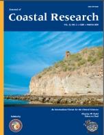
Rock Outcropping along the Coastline of the Sea of Cortez. The Sea of Cortez, also known as the Gulf of California, is estimated to have formed approximately 12 million years ago, as geologic forces rifted the Baja California Peninsula off of the North American Tectonic Plate. By doing so, a vast basin was created with contrasting bathymetry. In the northern region, the Sea of Cortez is relatively shallow (<200 m deep), due to the sedimentation of the redirected Colorado River, and is inhabited by many endemic species, including the endangered vaquita harbor porpoise, Phocoena sinus. On the other hand, the southern region is upwards of 3000 m deep, and contains the Guaymas trench, which is lined with numerous volcanic seeps and hydrothermal vents.
The rock formation pictured above is believed to be one of the many Neogene volcano-sedimentary rock outcroppings found along the coast of the Sea of Cortez. Ledesma-Vazquez et al. (2006) showed that such Pliocene volcanic and sedimentary units supply evidence that areas along the Sea's coast were originally part of a dry basin on land that later became a wave-dominated shoreline. (Photograph by Christopher Makowski, CPE Marine Science & Biological Research, Boca Raton, Florida, USA.)