Policy makers and resource managers in Hawai‘i often look to the ancient Hawaiian system of resource management, known as the ahupua‘a system, as a holistic and sustainable mountains-to-sea model for restoration of social-ecological system health and function. Many components of this ancient system, such as agriculture, aquaculture, and nearshore fishery management, have been documented, studied, and revived in the name of both sustainability and perpetuation of Hawai‘i's indigenous culture. One relatively glaring hole in the context of our understanding of this ancient system is management of forest resources on a system (i.e., large-scale plant community) level. Five terms for identified and managed social-ecological zones, wao kānaka, wao lā‘au, wao nāhele, wao kele, and wao akua, were used to delineate GIS layers in the model ahupua‘a of Hā‘ena. These were then extrapolated across the entire island of Kaua‘i. The resulting map indicates that not all ahupua‘a on Kaua‘i had all five social-ecological zones, which gives valuable insight into how upland regions of the various ahupua‘a may have been managed in the ali‘i era. This research has implications for contemporary approaches to large-scale biocultural conservation initiatives and other resource management plans that aim toward having broader community support for such efforts. Analysis shows that broad overlap between the ancient system and contemporary management zones exists, which implies that it may be feasible to adapt this ancient approach in the bureaucratic system of the contemporary era.
The term social-ecological system (Berkes et al. 2003) is applied to a human-inecosystem paradigm, which recognizes that human management of and influence in ecosystems is so pervasive that lines delineating between ecosystems and human systems are completely arbitrary and without sound scientific justification. In Hawai‘i, the social-ecological system in the ali‘i era, known as the ahupua‘a system, has long been a research interest for insights into how human communities can live sustainably within Hawai‘i's island systems ( Handy et al. 1972, Mueller-Dombois 2007, Winter and McClatchey 2008, Gonschor and Beamer 2014) and thus has become a model of biocultural conservation efforts and large-scale resource management programs that take a people-in-system approach.
In this article in the vein of social-ecological systems we contend that the term “social-ecological zone” can be applied to delineated management zones within such systems. These zones often differ from one another based on various factors such as substrate age/type, elevation, biological community, rainfall amounts, intensification of human presence/influence, restriction of certain practices, and other factors. The concept of social-ecological zones in the context of the ahupua‘a system is the focus of this research.
The Ali‘i Era in the Hawaiian Islands and the Ahupua‘a System of Resource Management
In the context of human presence in, and management of, social-ecological systems in the Hawaiian Islands there are several identifiable eras that mark major shifts in approaches to resource management ( Table 1). In the initial settlement period it is likely that various cultural groups came to Hawai‘i from different areas around the Pacific (Fornander 1919, Kamakau 1961), but relatively little has been documented from that era. Most notable among these are the Menehune and others whose cultures flourished before the ali‘i era and who were historically documented during the ali‘i era (Fornander 1919, Andrade 2008). The ali‘i era began when a migratory expansion came out of Tahiti and settled in Hawai‘i around 1,000 A.D. This approximate date is corroborated by archaeological data ( Wilmshurst et al. 2010). The ali‘i were a ruling class within this culture that eventually came to dominate the Hawaiian archipelago. They developed a structured and stratified system of management that was based on the ‘ai kapu religious system (also known as the kapu system) (Malo 2006).
The ahupua‘a system of resource management, which was utilized during the ali‘i era, divided an island into more or less self-sustaining communities, the majority of which extended from the mountains out into the ocean (Figure 1). Governance grew increasingly centralized in this era, but resource management remained decentralized in that it was place-based, with regulations that adaptively managed according to species abundance ( Handy et al. 1972) and other factors such as spawning periods for aquatic species (Titcomb 1972, Kahā‘ulelio 2006).
TABLE 1
The Different Eras That Correspond to Major Shifts in Approaches to Resource Management over the Course of History in the Hawaiian Archipelago

The ali‘i era ended with the abolishment of the kapu system in 1819 ( Kame‘eleihiwa 1992, Beamer 2014), an event that ushered in the kingdom era. Governance then moved more strongly toward a centralized system; yet despite that governance shift, resource management continued with the place-based paradigm of the ahupua‘a system (Gonschor and Beamer 2014). The kingdom era lasted until the overthrow of the monarchy by a party of plantation owners and businessmen in 1893, which was then followed by annexation by the United States of America in 1898. This ushered in the territorial era, which then lasted until statehood in 1959, and resource management transitioned into a standardized bureaucratic system that was not set up to adaptively manage according to species abundance. The era since then is known as the contemporary era, which remains in a standardized, bureaucratic-governance paradigm.
Knowledge relating to the management of the major components within the ahupua‘a system has some glaring holes. Much has been documented about agriculture systems ( Handy et al. 1972), nearshore fishery management ( Titcomb 1972, Kamakau 1976, Maly and Maly 2003b, Kahā‘ulelio 2006), and aquaculture ( Titcomb 1972, Wyban 1992) in the context of this management system; however, there is a paucity of information about the management of zones outside the habitation and field-cultivation zone, such as the agro-forestry zone and other forested areas. This research aims to shed some light into that realm and advance our understanding of upland and forest-resource management under the ahupua‘a system.
Figure1.
The boundaries of the ahupua‘a system of resource management for the island of Kaua‘i. GIS boundaries and names are delineated by the “historic ahupua‘a” layer provided by the State of Hawai‘i, Office of Hawaiian Affairs, and distributed by the Hawai‘i state GIS program ( http://planning.hawaii.gov/gis/download-gis-data / ). The different colors represent moku (districts), and the gray lines represent ahupua‘a boundaries, each of which is identified by name. The ahupua‘a used as a model in this study, Hā‘ena, is in the northwest corner of the moku of Halele‘a (indicated with a star).

Similarities and Differences in Classification Systems within the Hawaiian Islands
In the ali‘i era, each of the main islands was an independent kingdom before unification of these into one unified, archipelagoencompassing kingdom after the turn of the nineteenth century ( Kamakau 1961). Each kingdom had its own set of systems to understand the world around it, such as its own calendar (Abbott 1992), biological classification system ( Winter 2012), and lexiconic variations (Pukui and Elbert 1986). These systems were similar but differed in a few key details. These differences likely came about as a similar worldview was applied onto island systems that were comparable, yet differed in key physical and biological variables such as substrate ages, topographies, elevations, ecological zones, and biological communities. This is likely to be particularly true between the older islands (i.e., Kaua‘i and O‘ahu), which have well-developed soils and a higher percentage of ahupua‘a boundaries that more closely correlate to watershed boundaries, and the youngest island (i.e., Hawai‘i), which is generally not as deeply eroded, has shallow soils, and, as Gonschor and Beamer (2014) pointed out, has ahupua‘a boundaries that mostly did not correspond with watershed boundaries. It is, therefore, a conservative assumption of this research that there are variations in how social-ecological zones were perceived and described between the islands.
Differentiating between Terms Associated with Physical Features and Social-Ecological Zones
It is important to recognize the linguistic differences between terms applied to physical features of the landscape and social-ecological zones. Physical features of the landscape, such as mountains and ridges, will be physical features no matter how they are managed. On the other hand, social-ecological zones delineated management realms that were recognized as serving primary functions in the overall system. It was the synergistic effect of these zones, functioning in concert within the system, that provided the foundation for a perpetual abundance of resources that is known in Hawaiian by the term “‘āina momona.” For these zones to fulfill their role and function within the system, they were associated with particular human activities that were deemed as either appropriate or inappropriate. The boundaries of these social-ecological zones may have shifted over time or disappeared altogether, depending on population constraints and sociocultural priorities.
In the context of the Hawaiian language, terms indicating physical attributes of mountainous areas are indicated by the root word, “kua-,” and terms indicating social-ecological zones are indicated by the root word, “wao-.” Each of these root words is modified to differentiate between various kinds of physical features of the mountainous areas, and various kinds of social-ecological zones, respectively. The dictionary of the Hawaiian language by Pukui and Elbert (1986) included words from the lexicons of each of the Hawaiian Islands. They occasionally indicated which lexicon certain words sourced from, but they did not comprehensively explore the nuances of how the usage of these terms varied between the lexicons. Because of this, using the Pukui and Elbert (1986) dictionary alone may lead to confusion regarding usage and implementation of certain words, names, and terms that existed in the lexicon of each of the Hawaiian Islands. An assumption of many researchers is that the Hawaiian words documented by Pukui and Elbert (1986) were sourced from one complete lexicon, which leads to confusion about the usage of words and terminologies; but the reality is that Pukui and Elbert (1986) is a compilation of several closely related lexicons. A select list of terms that were documented for physical features of mountainous areas and social-ecological zones by Pukui and Elbert (1986) is given in Table 2.
A comprehensive listing of all documented social-ecological zone terminology used in the Hawaiian archipelago would be a substantial contribution to the historical understanding of resource management in the precontact era, but such research is beyond the scope of this article, which focuses on a single island.
Piecing Together the Puzzle of Social-Ecological Zones in Ahupua‘a
All known comparative descriptions of social-ecological zones come from the island of Hawai‘i, the youngest, tallest, and the least topographically complex in the archipelago. In this article we attempt to determine the social-ecological zones for the island of Kaua‘i, the oldest, third-tallest, and most topographically complex in the archipelago, using information that has been documented mostly from Hawai‘i Island. It is our contention that although terms regarding social-ecological zones were likely similar between the islands, their precise implementation and application likely differed based on both physical and biological attributes of the respective islands and the sociocultural systems that were built on these foundational elements. We, therefore, expect differences between the application of these terms on Kaua‘i and their application on Hawai‘i Island.
TABLE 2
A Select List of Hawaiian Terms Documented by Pukui and Elbert (1986) Relating to Physical Features of the Mountainous Regions as Indicated by the Root Word kua-, and to Social-Ecological Zones as Indicated by the Root Word wao-

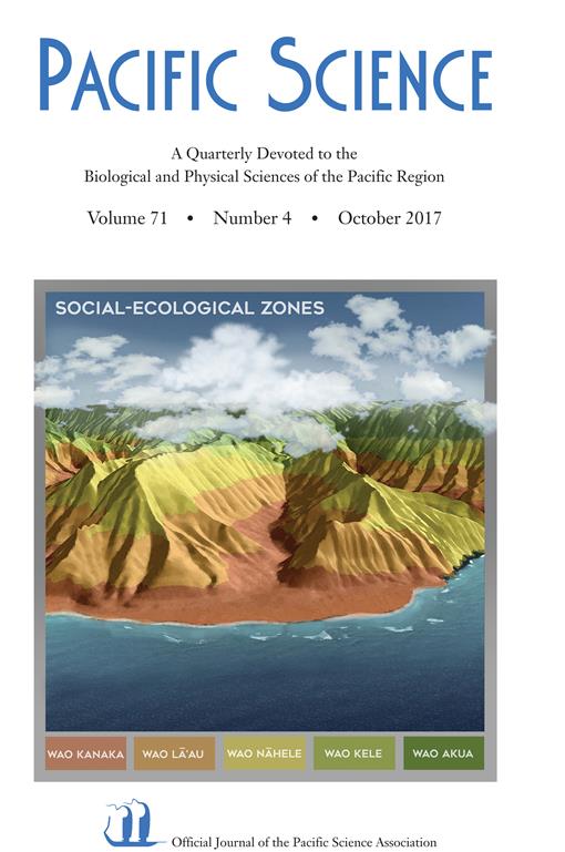
For the island of Kaua‘i, there was a system at least similar to that of Hawai‘i Island regarding the use of social-ecological zones in the ali‘i era, but the picture is not as complete. There are neither lists nor detailed descriptions of the social-ecological zones for the island of Kaua‘i as there are for Hawai‘i Island. However, there is reference to at least two in historical accounts during the ali‘i era: the “wao ‘eiwa” ( Kapohu 1869) [Note: in the context of Hawaiian-language literature, the term wao ‘eiwa seems to be a rarely used synonym for the term wao nāhele, which is a more descriptive and easily understood term; for ease of understanding by those familiar with the Hawaiian language, this social-ecological zone will henceforth be referred to only as wao nāhele in this article] and “wao lā‘au” (Hooulumahiehie-i-ka-oni-malie-a-pua-lilialana-i-ka-wai 1909), both of which are also documented for Hawai‘i Island. In these Kaua‘i references, the “wao ‘eiwa” is described as the upland forest where the ancestral gods (‘aumakua) dwelt in the area of Lïhu‘e; and the “wao lā‘au” is described as an upland area where canoe logs were felled in the ahupua‘a of Wailua. Beyond that there is also historical reference to the existence of the term “wao kele” in the ali‘i-era lexicon of Kaua‘i, but it was not associated with a specific place or practice ( Kapohu 1869). According to contemporary knowledge keepers, such as kumu hula, the terms “wao kānaka” and “wao akua” were also used by previous generations of Native Hawaiians on Kaua‘i (K. Kekua, pers. comm.). These five social-ecological zones were used in this analysis to develop a model of social-ecological system management on the island of Kaua‘i during the ali‘i era ( Table 3).
A commonly held assumption about the ahupua‘a system is that each ahupua‘a had all of the possible social-ecological zones. The aim of this research is to test that assumption. Our hypothesis is that some ahupua‘a have more identified social-ecological zones than others on the island of Kaua‘i.
TABLE 3
The Five Social-Ecological Zones That Appear to Have Been Recognized on Kaua‘i, the Oldest of the High Islands in the Hawaiian Archipelago, Which Has Well-Developed Soils and Ahupua‘a Boundaries That Closely Correspond with Watershed Boundaries; with Management Implications Provided for Each Zone

The Ahupua‘a of Hā‘ena as a Model
Hā‘ena (Figure 1) was one of the last intact ahupua‘a in all of Hawai‘i that was functioning as such into the contemporary era (Andrade 2008). The majority of its land is within the valley of Limahuli, which is owned and managed by the nonprofit organization National Tropical Botanical Garden ( NTBG), and its forested areas and archaeological sites have therefore been protected from development.
Hā‘ena is one of the most-studied ahupua‘a in Hawai‘i. NTBG has produced internal reports relating to biodiversity ( Wood 2006) and archaeology (Patolo 2001) and has collaborated on studies in hydrology and limnology ( Kido 1999, 2008, 2013; Sherwood and Kido 2002), ethnography (Maly and Maly 2003a), and social networks ( Vaughan and Vitousek 2013). In addition, a book has been written documenting its land-tenure history (Andrade 2008).
Given that so much time and effort has been devoted to documenting these important biological, archaeological, and ethnobotanical features; and that Limahuli Valley is topographically complex and possesses a biophysical gradient over a relatively small area, the ahupua'a of Hā‘ena serves as an ideal space to calibrate the spatial modeling of the social-ecological zones attempted in this study.
materials and methods
The five social-ecological zones determined to exist on Kaua‘i ( Table 3) were used to create a spatial model for the ahupua‘a of Hā‘ena on the northwestern side of the island. This model was then extrapolated out over the entire island.
Figure2.
Kaua‘i cumulative slope cubed cost surface as each cell moves away from the starting features of Ladefoged et al. (2009) Hawaiian agriculture model ( green) and augmented known Hawaiian habitation localities (white diamonds). The star indicates the location of Hā‘ena, the ahupua‘a of focus used for model training in this study.

Human-Use Zones as Cost Distance from Intensified Agriculture and Known Hawaiian Habitation
Ladefoged et al. (2009) used and validated a statewide Geographic Information System (GIS) modeling methodology [ArcGIS v10.1 (Environmental Systems Research Institute)] to understand and assess different fieldagriculturesystems utilized by Native Hawaiians in the ali‘i era. We assumed that intensified agriculture would serve as a good island-wide estimate of where ali‘i-era Hawaiians worked and lived. As such, this modeled area of prime flooded and rain-fed agriculture, as well as four additional sites ( Nu‘alolo Kai, Miloli‘i, Mānā, and Kïpü Kai) that are known agricultural complexes ( Handy et al. 1972, Kahn et al. 2016) not included in Ladefoged et al. (2009), served as a starting area for our cost-distance modeling (Figure 2), which was used to delineate the two lowest-elevation and most human-useintensified social-ecological zones, wao kānaka and wao lā‘au (see Figures 4 and 5).
Cost-distance analysis is used to calculate the cumulative travel cost and has become an established method used to model and assess the cumulative travel cost of animal movements in fragmented landscapes (Adriaensen et al. 2003). As such it has also been applied to landscape archaeological research as a technique for modeling human movement as a means to explore past social landscapes of indigenous people in the distant past ( Howey 2007, Taliaferro et al. 2010). We used cost distance as a tool available in GIS to calculate the cumulative sum surface of an assigned cost raster as each cell moves away from designated starting features. The cost raster is a single or composite raster of any designated cost criteria. The units assigned to the cost raster can be any type of cost desired.
Our conceptualization of social-ecological zones is a function of human-energetics expenditure and logistical-feasibility cost associated with travel to distant and /or steep areas from known and modeled agriculture sites. The cost layer created for this analysis was the slope cubed (i.e., slope value3 of the island of Kaua‘i). The slope3 cost raster delineates extremely steep areas that are energetically expensive for human management yet still have a close linear distance to agricultural areas as a higher cost. By assigning such an extreme exponential cumulative cost to areas of high slope we control for the large amount of extreme topography found on Kaua‘i that is relatively close to documented agricultural and housing sites associated with the ali‘i-era infrastructure.
Creating a Model for Social-Ecological Zones in the Ahupua‘a of Hā‘ena
A spatial model was created to delineate the five social-ecological zones [that have been documented for the island of Kaua‘i ( Table 3)] within the ahupua‘a of Hā‘ena in the northwestern corner of the island. Ladefoged et al.'s (2009) precontact Hawaiian agricultural model along with four additional sites of documented Native Hawaiian inhabitance (white diamonds in Figure 2) ( Handy et al. 1972, Kahn et al. 2016) served as the initial input for which slope3 cost distance was calculated. This cumulative cost raster served as our foundation for delineating the two lowest-elevation social-ecological zones, wao kānaka and wao lā‘au, respectively, as well as the lower boundary for the other less intensely managed social-ecological zones. To apply cumulative cost distance of slope3 value ranges to Hawaiian ecological management zones we used GIS layers of known archaeology and digitized locations of remnant agroforestry patches as indicators of the past Hawaiian footprint in Hā‘ena. Finally, the less intensely managed social-ecological zones are delineated beyond a range of cumulative cost distance and are separated by biologically confirmed moisture zones and /or modeled cloud formation and topographic intercept. The parameters for each are described in detail below.
wao kānaka: This social-ecological zone was classified from the lowest values of our cumulative cost raster. The upper values of this zone were defined within Limahuli Valley when the range of the cumulative cost that defined this “intensified human-use zone” encompassed the majority of the mapped Hawaiian archaeological sites (see Figure 5). This was done by extracting all the cumulative cost-distance values within the known archaeological sites, then calculating the mean of that, and finally adding a standard deviation to define the upper boundary of this zone. This widening of the range of cumulative cost resulted in the inclusion of approximately 88% of the actual documented Hawaiian archaeological areas within Limahuli Valley. Applying these values to the rest of Kaua‘i resulted in the connection of the patches of other modeled agricultural areas associated with the ali‘i era across Kaua‘i. This combination simulates what the ali‘i-era human-use zone, wao kānaka (i.e., realm of humans) management zone potentially looked like across Kaua‘i's accessible lower elevational areas.
wao lā‘au: This social-ecological zone has to be logistically feasible for perpetual forestry (i.e., timber and nontimber forest products) management and extraction. As such, the wao lā‘au shares its lower border with the upper boundary of the wao kānaka. Within Limahuli Valley we delineated this zone by mapping existing groves of Polynesian-introduced kukui trees (Aleurites moluccana) from high-resolution Pictometry imagery (Pictometry International, Henrietta, New York) (Figure 3), extracting all cumulative cost distance above the wao kānaka within these mapped kukui grove polygons, calculating the mean cumulative cost, and then adding one standard deviation to define the upper boundary of this zone. Kukui trees were chosen because of their known ethnobotanical value and role in agroforestry by Native Hawaiians ( Handy et al. 1972), as well as their easily distinguishable light green leaf color (Figure 3). Despite the fact that the mapped patches of existing kukui trees are generational descendents from the original Native Hawaiian — planted kukui grove locations, and it is possible that the original locations of these plantings may have shifted or spread over time, the defined range of cumulative cost encompassed approximately 82% of current kukui grove area located above the wao kānaka. The upper boundaries of this zone are aimed to represent values of cumulative cost where impassable landscape features such as cliffs and extreme slopes would not permit this management activity. The range established from this method closely aligns with these known impassable topographic features within Limahuli Valley (see arrows in Figure 3). Thus, when these ranges of values are applied to the entire island of Kaua‘i, this zone delineates areas where it may be logistically feasible for active agroforestry and other resource management associated with this zone. As such, the remaining upper-zone locations are beyond the limits of feasible intensive resource management.
wao nāhele: This social-ecological zone is beyond the practicable area for resource management and extraction ( Table 3). The wao nāhele zone is ecologically aligned to dry and mesic moisture areas. A U.S. Geological Survey ( USGS)-produced layer of ecological moisture zones served as the spatial layer that defined areas on a gradient from dry, to mesic, to moist, to wet (Price 2012). The wao nāhele zone was delineated as any dry to mesic [i.e., moisture zones 1–4 in Price (2012)] area found above the upper boundary of the wao lā‘au.
wao kele: This social-ecological zone is similar to the wao nāhele. It is ecologically defined as areas of wet forest beyond the realm of feasible intensive forest resource management. Thus moist-to-wet and very-wet ecological zones (moisture zones 5–7) as defined by USGS (Price 2012) serve as the factor separating this wet zone from the dry wao nāhele. In dry areas the lower boundary of this zone is shared with the wao nāhele, but in wet areas the upper boundary of the wao lā‘au serves as the zone's lower boundary. Both of the wao kele and wao nāhele upper boundaries are always defined by the lower limit of the wao akua.
wao akua: This social-ecological zone has been described as the cloud forest ( Kanahele 2003). As such we delineated the lower boundary of this zone by estimating where clouds form and intersect the landscape on Kaua‘i. This was done by calculating the lifting condensation elevation to estimate cloud base height formation and calculate whether this cloud formation occurs below or at the surface elevation of landscape features on Kaua‘i. The University of Hawai‘i Geography Department's Hawaiian climate data (Giambelluca et al. 2014) provided spatial rasters of mean monthly-hourly relative humidity (RH ). The mean monthly-hourly averages of relative humidity (n = 288) were resampled to 10 m resolution using a cubic convolution resampling in ArcGIS v10.1 to align elevation data. Using equation 23 from Lawrence (2005), the resampled mean monthly-hourly RH rasters were used to calculate the mean monthly-hourly lifting condensation level as an estimate of cloud base formation. Each of these spatial mean monthly-hourly cloud base height calculations was then subtracted from a 10 m digital elevation model (DEM) of Kaua‘i provided by USGS. Positive values from this calculation represented where cloud formation intersected the landscape. All positive cells from mean monthly-hourly cloudlandscape intercept estimates were converted to a value of one, summed with all other reclassified mean monthly-hourly cloud intersect estimates, and divided by the total number of mean monthly-hourly observations (n = 288) to create a spatial raster of percentage of mean occurrence of cloud-landscape intersection. A final value of 95% of estimated mean cloud-landscape intersection was used to delineate the boundary of cloud-immersed forest area used to define the wao akua. The resulting space is intended to represent where, probabilistically, clouds regularly form and intersect topographic features. The upper level of this zone encompasses the highest topographic features on the island of Kaua‘i and is aligned well with known areas of cloudand fog-dominated forest. Because it is the uppermost terrestrial social-ecological zone on Kaua‘i, the wao akua serves as the uppermost boundaries for all zones it borders.

Comparing Social-Ecological Zones of the Ali‘i Era with Management Zones of the Contemporary Era
A comparison was made between the model produced by this research and the existing management zones as determined by the State of Hawai‘i government. The modeled social-ecological zones were compared with the current Hawai‘i State Land Use Commission and State Land Use District Boundaries (see Figure 6). The percentage of the total area of each modeled social-ecological zone that occurred within each State Land Use District zone was calculated using the Tabulate Intersection tool in ArcGIS v10.1. This was done as a means of assessing the feasibility of applying the ancient resource management strategies, explored in this research, within the context of the centralized bureaucratic structure that is in place in the contemporary era.
results
The Model of Social-Ecological Zones on Kaua‘i in the Ali‘i Era
Based on the methods described here a spatial model was created for the ahupua‘a of Hā‘ena (Figure 4), and then this model was applied to the entire island of Kaua‘i (Figure 5).
The spatial model was applied over 53 ahupua‘a around the island of Kaua‘i. According to the model not every social-ecological zone was present in every ahupua‘a; most social-ecological zones had a different percentage of presence on the island ( Table 4, Figure 5).
The percentage of area coverage that the five social-ecological zones had on an island scale in the model showed that a majority of the land was classified as wao kānaka, followed sequentially in decreasing area coverage by wao lā‘au, wao akua, wao nāhele, and finally wao kele ( Table 5).
According to the spatial model, the total area that each social-ecological zone covered differed in each moku. Puna had the largest area designated as wao kānaka. Kona, being the largest moku, had the largest area designated for three social-ecological zones: wao lā‘au, wao nāhele, and wao akua. Halele‘a had the largest area designated as wao kele ( Table 6).
According to the spatial model, the percentage of area that each social-ecological zone covered differed in each moku. Four of the five moku, Halele‘a, Ko‘olau, Puna, and Kona, had the majority of their land designated as wao kānaka. Nāpali was the only moku that didn't have the majority of its land designated as wao kānaka; the majority of its land was designated as wao lā‘au ( Table 7).
The results of analyzing the data in four different ways ( Tables 4–7) show that the amount of area covered by each social-ecologicalzone varied from ahupua‘a to ahupua‘a and from moku to moku.
Comparing Ancient Social-Ecological Zones With Contemporary Bureaucratic Management Zones
Broad zone categories representing human habitation and land manipulation areas, along with natural land use and conservation areas for both modeled social-ecological zones and State Land Use District Boundaries, show strong agreement (Figure 6, Table 8). The largest percentage of disagreement exists between the modeled wao lā‘au zone and the state-planned conservation zone, but the overall majority of this particular delineation of social-ecological zones on Kaua‘i is in consensus with the State of Hawai‘i Land Use Districts.
discussion
Analysis of the Spatial Model
The spatial model produced in this study for the ahupua‘a of Hā‘ena had a strong fit when compared with the remaining physical evidence of the ahupua‘a system, such as archaeological sites. However, when these data were extrapolated out over the rest of Kaua‘i it produced an island model that did not conform to the current understanding of known agricultural and habitation sites for some areas. To address this inconsistency, archaeological site locations were inserted into the island model for the ahupua‘a of Miloli‘i, Nu‘alolo Kai, Kïpü Kai, and Mānā based on data from State archaeological reports and other sources ( Handy et al. 1972, Kahn et al. 2016). This produced a much more plausible island model.
Figure4.
A spatial model of the social-ecological zones of the ali‘i era within the ahupua‘a of Hā‘ena.

Figure5.
The spatial model for social-ecological zones of the ali‘i era applied to the entire island of Kaua‘i. The star indicates the location of Hā‘ena, the ahupua‘a of focus used for model training in this study. Boundaries represent historic ahupua‘a as provided by State of Hawai‘i Office of Hawaiian Affairs and distributed by the Hawai‘i state GIS Spatial program ( http://planning.hawaii.gov/gis/download-gis-data/ ).

TABLE 4
Percentage of Presence of Each Social-Ecological Zone within the Ahupua‘a of Kaua‘i as Indicated in the Spatial Model

TABLE 5
Percentage of Area Coverage of Each Social-Ecological Zone in the Ahupua‘a of the Island of Kaua‘i as Indicated in the Spatial Model

TABLE 6
Total Area of Coverage of Each Social-Ecological Zone According to Moku (District) for the Island of Kaua‘i as Indicated by the Spatial Model

TABLE 7
Percentage Coverage of Each Social-Ecological Zone According to Moku (District) for the Island of Kaua‘i as Indicated by the Spatial Model

On an island-wide scale, the area designated as wao kānaka in the spatial model was by far the largest of all the social-ecological zones. In addition to this, the modeled wao kānaka zone is notably larger than the model for the Hawaiian agricultural footprint put forth by other researchers (Ladefoged et al. 2009). This result was expected because the Hawaiian agricultural footprint is a model of the areas where forest was converted into intensified field agriculture, habitation sites, clearings for recreational spaces, and for the construction of temple (heiau) complexes; but that footprint exists within the wao kānaka zone rather than representing the boundaries of it.
It is an important point of understanding that the wao kānaka zone does not connote the extent of complete deforestation in the ali‘i era. If there were no compelling reasons to convert forests, and especially if there were compelling reasons to leave them standing, then forests were left in place. Although the wao kānaka designation was intended to zone an area as acceptable for potential augmentation of the landscape, as a means to maximize the availability of food, medicine, and other key resources, under some circumstances leaving areas as forested in the human realm constituted their highest and best use. An example of this is the coastal hala (Pandanus tectorius) forest of Naue, which was famous for the weaving material that it produced (Pukui 1983, Maly and Maly 2003a). This coastal forest of intensified human use was honored in the ali‘i era and remained both intact and intensively used by the community at the eastern border of Hā‘ena until it was wiped out by the tidal wave of 1946 (Maly and Maly 2003a).
Figure6.
Current Hawai‘i State Land Use Commission, State Land Use District Boundaries of the island of Kaua‘i, provided by State of Hawai‘i Office of Hawaiian Affairs and distributed by the Hawai‘i state GIS program ( http://planning. hawaii.gov/gis/download-gis-data / ). The State Land Use Districts depicted in this map and analyses are not official and are merely representations for presentation and discussion purposes only.

TABLE 8
Cross-Validation of Percentage of Total Area of Each Modeled Social-Ecological Zone ( Rows) That Occur within Each Hawai‘i State Land Use Commission, State Land Use District Boundary Zone (Columns)

The concept that forested areas existed within the wao kānaka zone of the ali‘i era is worthy of further exploration. Forested areas remaining within the zone of human usage might have made these areas more practical to manage for timber and nontimber forest products, as with the example of the hala forest of Naue discussed earlier. This could be because the cultural and /or religious protocols (e.g., chants, prayers, offerings, etc.) associated with entering a different social-ecological zone might not have been required before entering the wao kānaka forest to tend, gather resources, or otherwise enjoy the space. Given the known existence of forested areas within the wao kānaka, and the fact that there is no evidence that deforestation was an accompanying mandate of this designation, it is safe to assume that large areas of forest existed within this zone through the end of the ali‘i era.
When comparing the model produced by this research and the historic reality regarding the boundaries of the wao kānaka, there are likely to be some discrepancies. The evidence we have to assess the accuracy of this model is limited because a substantial amount of archaeological complexes/sites and agroforestry systems were destroyed in the nineteenth and twentieth centuries when sugar plantations and subsequent development took over much of the lowlands on Kaua‘i. This essentially erased the evidence of what once existed. More research into this area could provide a stronger foundation to refine the model in the future.
The area designated as wao lā‘au in the spatial model was determined using a mathematical calculation. Actual areas of highly tended forest in the ali‘i era were based on nonmathematical factors such as water availability, frequency of visitation, and other such factors. We have noted discrepancies between the model and reality for this social-ecological zone and they could be due, but not be limited, to the following possibilities:
(1) The population had not yet expanded to its full potential, and thus the agroforestry zone was not completely converted to highly-tended forest.
(2) Biological indicators (i.e., botanical footprints) may have been lost over time.
(3) Scale issues with the topographic rasters might not accurately represent all potential ground accessibility (via such things as trails and the use of ladders), which could make other areas more feasible for management. Conversely, other areas identified as accessible in the model might not have been actively managed due to biophysical issues such as substrate type or water availability.
More research into this area could elucidate which of these possibilities is the most likely.
The discrepancies between the model and historic reality of the remaining three wao (wao nāhele, wao kele, and wao akua) are more challenging to speculate about given that so little has been documented about these zones. Of worthy note, the model uses areas of cloud intercept data from a postclimatechange era to delineate the wao akua. Under the context of climate change, it is assumed that the cloud data used in this model are not accurately reflective of the cloud intercept areas in the ali‘i era, but without complex climate modeling this is the best data we have to delineate this zone.
An Emergent Picture of Ahupua‘a Management in the Context of Social-Ecological Zones
The results of this model indicate that there are various social-ecological zones above the human habitation areas. It also provides further evidence that the ahupua‘a concept was not applied with a cookie-cutter approach, but rather was highly dependent on biophysical features of the landscape within the boundaries of each ahupua‘a.
Another implication of this research is that not all ahupua‘a and moku had the same abundance of resources. Each social-ecological zone had a function within the larger social-ecological system. Having more area designated as one social-ecological zone over the others ( Tables 4–7) might indicate higher abundance of the associated resource products of each zone such as food (wao kānaka), timber and nontimber forest products (wao lā‘au), passerine feathers (wao nāhele), and fresh water (wao kele and wao akua). Further research could look into resource abundance according to the respective ahupua‘a.
Application of Kaua‘i's Social-Ecological Zone Designations on Other Islands
The results of this research were based on some assumptions about the use of social-ecologicalzone terminology and moved forward with the most complete understanding of how these terms and classifications were used on the island of Kaua‘i. It is entirely possible that more archival or other data will emerge as to the usage and implementation of social-ecological zones on Kaua‘i in the ali‘i era. If and when that happens, the model that produced the results of this study will need to be amended.
All indications are that each island had its own classification system for the social-ecological zones found there during the ali‘i era. Therefore, we urge caution when using the results and conclusions of this research for islands other than Kaua‘i.
Implications for Large-Scale Conservation and Restoration Efforts
Conservation efforts in Hawai‘i have historically faced many challenges over the past few decades for many reasons, lack of engagement and support on behalf of the local community being one of them. This has been due, in large part, to where and how certain conservation tools, such as fencing and ungulate control, have been implemented in and around Native Hawaiian and other rural communities ( Winter and Clark 2015). Comanagement efforts that take a biocultural approach ( being aligned with community priorities and founded in cultural values) can increase community engagement and thus garner more support for conservation efforts than ones that exclude communities and indigenous cultural perspectives.
With the onslaught of invasive species and the impacts of global climate change, largescale conservation and restoration efforts need to utilize new tools, but that does not mean that these efforts need to reinvent the wheel. Long-term success of conservation efforts is more likely when they are built off of an engaged and supportive local community. Having a better understanding of traditional forest management can help to inform policy makers and resource managers about where to use specific conservation tools and how to use them in such ways as to garner greater support from the local community.
Two of the most controversial methods for large-scale forest restoration in Hawai‘i include the construction of exclusion fences and the creation of hybrid forests. Both of these approaches could be set up for a better likelihood of success if they are built upon the conservation ethic that has long existed within Hawaiian culture and if they are founded in approaches that were taken in the context of the ahupua‘a system. As one example, the approach of fencing feral ungulates out of core watershed areas might be better accepted by larger portions of the local community if it was presented as an attempt to protect the integrity of the sacred forest (wao akua). As another example, the notion of creating large areas of hybrid forest, which is composed of both native and introduced trees, might be better accepted if it is presented as a modern application of an ancient practice (associated with the wao lā‘au designation) that aimed at maximizing the ecosystem services of a forest. This research provides a foundation of common understanding for such conversations to take place.
Applications of This Research on Kaua‘i and across the Archipelago
The broad overlap between the ancient social-ecological zones of this model and the existing management zones developed by state government for the island of Kaua‘i means that there is the potential for adapting Hawaiian resource management strategies within the existing system of the contemporary era. The only social-ecological zone in question is the wao lā‘au. However, because the wao lā‘au zone is intended for an enriched forestry system aimed at sustainable resource extraction, many of the ancient land-use practices associated with this zone may comply with contemporary state laws mandating allowable conservation land-use actions (such as forestry and agroforestry).
With few exceptions, contemporary conservation and agricultural practices on a large scale have historically not been aligned with the intended purposes of ali‘i-era social-ecologicalzones. Encouraging comanagement in both biological conservation efforts and in local agriculture/agroforestry in a system context could maximize the synergy between biological conservation and cultural /community resilience.
conclusions
Although the spatial model produced in this study applied a quantitative approach, the reality is that the social-ecological zones of the ali‘i era were based on an assessment of both biophysical and sociocultural variables of that time period, which this study does not account for. Because of this, we make no claim that the model presented here accurately matches management zones at any point in time. It does, however, serve its purpose of providing a model of understanding for the management of forest resources in the ahupua‘a system of the ali‘i era and of providing a foundation to have conversations about how contemporary conservation efforts can align with community priorities and cultural values.
This model presents only one particular delineation of the five social-ecological zones documented for Kaua‘i, but we explored other model scenarios. These explorations resulted in various expansions and /or contractions of human-use zones and watershed conservation zones, but none of these permutations produced consistent or equal zone occurrence across ahupua‘a boundaries or moku districts. Therefore, the results of our approach do suggest that the proposed hypothesis, regarding the notion that not all ahupua‘a on Kaua‘i had the same amount of social-ecological zones, is supported. It also supports the notion that the ahupua‘a concept was not applied across the islands in a standardized, cookie-cutter approach; but rather that the implementation of the concept was adjusted to account for biophysical parameters at least. This likely resulted in some ahupua‘a and moku having more abundance of some, but not all, key resources (food, timber and nontimber forest products, passerine feathers, and fresh water) than others.
This research has developed a model and produced maps that allowed for further insight into how ahupua‘a may have been managed in the ali‘i era, with particular regard to inland forest resources. Better data about archaeological sites throughout the island will help to refine the model presented in this research and thus provide an opportunity for future research. Based on what is seen in our results, we feel that if this model were transposed over other islands it would likely lose strength, particularly with the younger islands in the archipelago, and we, therefore, advocate for producing island-specific models in such future research.
The results and conclusions of research can help to guide resource managers and policy makers who take a biocultural approach to making decisions about resource conservation. Such approaches, that are both ecologically important and culturally sensitive, likely have a better chance of support from local communities surrounding conservation efforts and, thus, a better chance at long-term success. An analysis comparing the social-ecologicalzones of the ali‘i era with the bureaucratic management zones of the contemporary era show broad overlap, which means that it may be feasible to incorporate ancient approaches in a modern period as a means to more holistically manage for an abundance of biocultural resources. In that regard, this research could potentially help to direct large-scale holistic planning in the Hawaiian Islands.
acknowledgments
We acknowledge the following people and organizations without whom this research would have been impossible. Mahina Patterson helped to inspire the direction that this research ended up taking. We had conversations with many people who gave insights into the foundations of this research. Among them are Kamana Beamer, Lei Wann, Pelika Bertleman, Chipper Wichman, Carlos Andrade, Bruce Wichman, Randy Wichman, Sam Gon, Këhaulani Kekua, D. Kamealoha Forrest, S. Kekuewa Kikiloi, Malia Akutagawa, Erik Burton, Kepā Maly, Fikret Berkes, Peter Vitousek, and Will McClatchey. In addition, thanks to Han Tseng at the University of Hawai‘i at Mānoa and Ben Nyberg at the National Tropical Botanical Garden. Thanks, also, to the ESRI Conservation Program (ECP) for their continued GIS support to the National Tropical Botanical Garden. Resources for this research were provided by National Tropical Botanical Garden. Mahalo.